Danny and Little Danny

•April 28, 2008 • 1 Comment

Up!

Last week you may recall my mentioning a photo shoot in Puerto Rico. Well, my client was kind enough to allow me to share a few of the shots from that session – thank you Danny! Danny and his 8 month old son Little Danny have a very close bond, and shooting these photos was truly a pleasure.

These shots were taken with my D300 and a 50mm ( f1.8 ) lens in natural light at Danny’s home in the mountains of Puerto Rico. The drive to Danny’s house was hair raising, which will be no surprise to those of you who drive in the mountains. In fact, I have met a number of people who flat out refuse to drive up there at all!

Close

I think this is my favorite from the shoot. It was a great moment to witness.

See me?

I loved seeing father and son interact, and the lens seemed to pick it all up very well.

Huh?

Did someone say dinner is ready?

Trio

Mom looks on as we play around and have fun.

Keys Please...

Next Little Danny will be asking for the car keys.

Comfort

Nothing beats hanging out with Dad!

I’d like to thank Danny and his lovely wife for their gracious hospitality and for the opportunity to capture their young son in images that will please them for a long time. I enjoyed myself thoroughly, and I learned a great deal from the experience.

I’ll be doing another shoot with these three in Condado very soon using a beach theme, so stay tuned for more portraits from the Caribbean.

Advertisement

The Comforts of Home

•April 19, 2008 • Leave a Comment

Coffee Making Essentials

Just a quick post today from home, before I head back to the islands for another trip and -breaking news- a paid photo session doing portraiture!

Gathered here is a very quickly composed shot from my kitchen. As many of you know, I love to cook for fun and relaxation. Among my kitchen essentials are the burr grinder and milk frother for espresso, my lovely knives, my olive oil, and my pilón from the Dominican Republic. I did a little research about the pilón, since it is such a staple of latin cooking, and here is what I learned.

It turns out that the pilón was first used by the Taíno Indians. Conquistador historians like Fray Iñigo Abbad, and Fernández de Oviedo mention having seen the Indians use giant size vases to mash different things. The ancient pilones were much like the pilones of today. Same shaped but quite rustic. Taínos would step one foot on the base to prevent it from tipping over when hit with the giant macetas. Taínos used large hollowed out tree trunks to form waist high pilones. The hole was approximately 25 inches in diameter – of course they often varied in size. Some were small hand-held pilones but still larger than the ones we use today. Since Taínos used them – pilones were found in all the Caribbean Islands. The hole for the pilón was burned out and carved using simple rustic tools. Giant macetas were carved out of trees also.

The final product depended on the talents of the carver. Some were very rustic, most were just plain practical. Some were well finished smooth and shiny on the outside. Some were pieces of art with elaborate carvings but I’ve never seen any of those myself. Pilones found in Haiti tend to be more elaborately decorated, even today. Taínos used the pilón and maceta to mash corn, spices, medicinal herbs and other things. Ingredients to make body paint were also processed in a pilón. With the introduction of the coffee bean into our culture, the pilón took an even more prominent place in our history.

Mine was hand made, hand picked, and even hand delivered and I wouldn’t part from it without a fight.

Casper in the sun

Just aorund the corner from my kitchen is the patio. During the temperate months, this is a great place to enjoy the hummingbirds, butterflies, and a refreshing iced beverage. I’ve become a fan of the Mojito… hey, if it was good enough for Hemingway, it is certainly good enough for me.

Flower1

Springtime is flower time, and despite our precious meadow being flattened and made into town houses there are still wildflowers here and there. My flower knowledge is even weaker than my bird skills, so I’ll leave the identification bit to more competent hands.

Flower2

Another gratuitous flower shot. They are just too pretty NOT to take pictures of, ya know?

For the Birds!

•April 15, 2008 • Leave a Comment

The Manor

Since the cherry blossom post was such a hit, I thought I’d share a few more photos from where I reside in Virginia, being that it is springtime and there are so many beautiful things to see here. We are very fortunate to have had, in our town, a very wealthy family which decided to bequeath their estate to the Audubon Society. The former estate is now a nature preserve, albeit a relatively small one, which supports an old hardwood forest, a pine forest, a spring fed pond, and a very large meadow. The grounds are fantastic, and the number of birds which transit the preserve throughout the year is impressive. I’m not a bird guy, so I’ll refrain from even trying to identify the subjects of my photos – if you are a confident birder, then please, share your knowledge with us!

Peekaboo

This fella was playing peekaboo with me, darting all around and peeking out when I wasn’t looking.

Friends

The feeders around the manor were attracting several species, all of whom were sharing the perches.

Dinner

This hawk was about 120 yards off, enjoying a rodent from the nearby field. This shot was handheld, and frankly I am shocked that it came out with ANY clarity. The bird was just a dot in the lens. After a couple of minutes, another hawk (a mate?) came by and squawked enough to make this one take flight with the mouse dangling.

Cleared for Landing!

OK, I said I wasn’t going to try identifying the birds, but this one seems to look like a goldfinch. The next few frames were shot with a 70-200mm zoom (f2.8), which produces some very nice, crisp shots… even at 200mm.

Alllmost Theeere!

Almost there! Looks like the Missus was already enjoying an afternoon snack.

Isn\'t love grand?

Isn’t love a beautiful thing?

Meanwhile, on the gorund...

Meanwhile, on the ground, some LBB’s (little brown birds) were busy foraging in the grass. This one was quite pretty, I thought.

I\'m a bird....

OK, this isn’t a bird, but Ms. Squirrel sure acted like one! I had a lot of fun shooting this series of photos – it was a departure from my usual shots of people and places. Hey, if you’ve got a camera, get out there and get some shots of your local wildlife. I promise, you won’t regret it!

The Cherry Blossoms

•April 10, 2008 • 1 Comment

Having just returned from a meeting in Toronto, Mary and I decided to peruse the Tidal Basin in Washington DC where the world famous cherry blossoms were said to be in bloom. I’m glad that we did. The National Cherry Blossom Festival was just about to kick off, and by visiting on a weekday we avoided the crowds.

For my friends in the Caribbean and elsewhere around the world: The National Cherry Blossom Festival annually commemorates the 1912 gift to the city of Washington of 3,000 cherry trees from Mayor Yukio Ozaki of Tokyo to enhance the growing friendship between the United States and Japan and celebrate the continued close relationship between our two peoples.

In a simple ceremony on March 27, 1912, First Lady Helen Herron Taft and Viscountess Chinda, wife of the Japanese ambassador, planted the first two of these trees on the north bank of the Tidal Basin in West Potomac Park. By 1915 the United States government had responded with a gift of flowering dogwood trees to the people of Japan. In 1927, a group of American school children reenacted the initial planting; the first festival was held in 1935, sponsored by civic groups in the nation’s capital.

On the Steps

Mary relaxes for a moment on the steps of the Jefferson Memorial, Cherry Blossom goods in hand. What many folks don’t know about the cherry trees around the tidal basin is that it is an ongoing project which has spanned many generations.

In 1965 three thousand, eight hundred more trees were accepted by First Lady Lady Bird Johnson. In 1981 the cycle of giving came full circle. Japanese horticulturalists came to take cuttings from our trees to replace Yoshino cherry trees in Japan which had been destroyed in a flood. With this return gift, the trees again fulfilled their roles as a symbol and agent of friendship. The most recent event in this cycle occurred in the fall of 1999. It involved the formal planting in the Tidal Basin of a new generation of cuttings from a famous Japanese cherry tree in Gifu province reputed to be over 1500 years old.

In 1994 the Festival was expanded to two weeks to accommodate the many activities that happen during the trees blooming. Today the National Cherry Blossom Festival is coordinated by the National Cherry Blossom Festival, Inc., and over a million people visit Washington each year to admire the blossoming cherry trees and participate in the Festival that heralds the beginning of spring in the nation’s capital.

From the Inside: Impressions of El Morro

•April 7, 2008 • Leave a Comment

Entrance Herald

In previous posts, I have mentioned the grand old fort of Puerto Rico: El Morro. So I’ll skip the historical review of this majestic citadel and dive straight into the photos. As I entered the stronghold, the royal coat of arms and pillars immediately transported me to the early colonial period.

These iconic garitas have been widely recognized as symbolic of Puerto Rico. I can imagine standing watch through the night, looking out across the campfires of the settlement, ships masts standing tall in the harbor under the tropical moon.

Hold.... HOLD... FIRE!

The 9 pounders (and larger cannon) on the site are silent now, but they were deadly in their time. This one peers across San Juan Bay looking for marauders. Archaeological efforts are ongoing here, which was really nice to see.

I’d actually trade in my current job for a slot working as a guard at El Morro in the 18th century. This office space may not have all of the comforts of 21st century living, but I’d do it just the same. I’ll bet the rum tasted better back then…

There are 6 levels within El Morro, and many of the interior buildings are reasonably well preserved. There are stores room, powder magazines, stables, barracks, dining halls, and all of the other structures one would expect to see in a small city.

OK, just one more garita. The ones overlooking the ocean are best of all!

I wasn’t the only one taking pictures today… here’s my daughter with her point and shoot taking some very well-composed shots of her own.

El Morro is the kind of place that transports you to days long past – you just can’t help it! The narrow cobblestoned corridors, the fantastic views, and the nooks and crannies make this a fun visit for just about anyone.

The Secret Garden

•March 30, 2008 • 2 Comments

Entering the Secret Garden

Located deep within Old San Juan on Calle de San Francisco there exists a small park – a secret garden known only to locals. While checking out the nearby La Forteleza, be sure to seek out this sanctuary, hidden behind rising palms on a residential street. You’ll have to look closely, or you’ll walk right by…

Lovely!

Many are the treasures you’ll find! There are bakeries nearby, which make an impromptu picnic a pleasant possibility. My dear Mary, who has lived in San Juan for over 20 years, had never heard of this secret garden. Needless to say, she was surprised!

Four Beaches and an Alcapurria

•March 23, 2008 • 1 Comment

Today we set out to hit the corners of Puerto Rico, visiting four beaches: Playa de Ponce, Luquillo, Cabo Rojo, and Pinones. Each beach has its own distinctive flavor, from pebble-strewn to talcum powder sand and clear water.

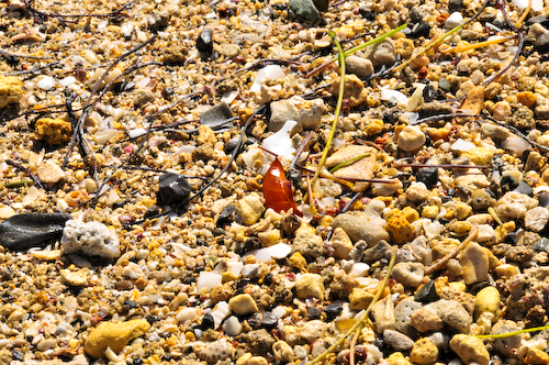
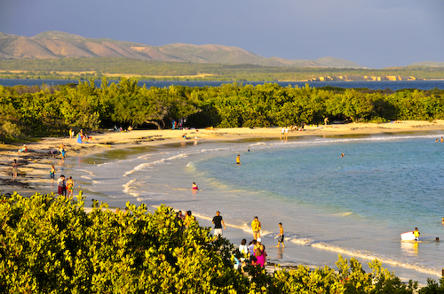
Our first stop was Playa de Ponce, which is on the arid southern shore of Puerto Rico. The beach sand, shown above, isn’t actually sandy. It is a collection of roughly crushed coral and seashells which make for rather uncomfortable beach lounging, but the opportunity to collect sea shells is quite good.

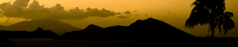
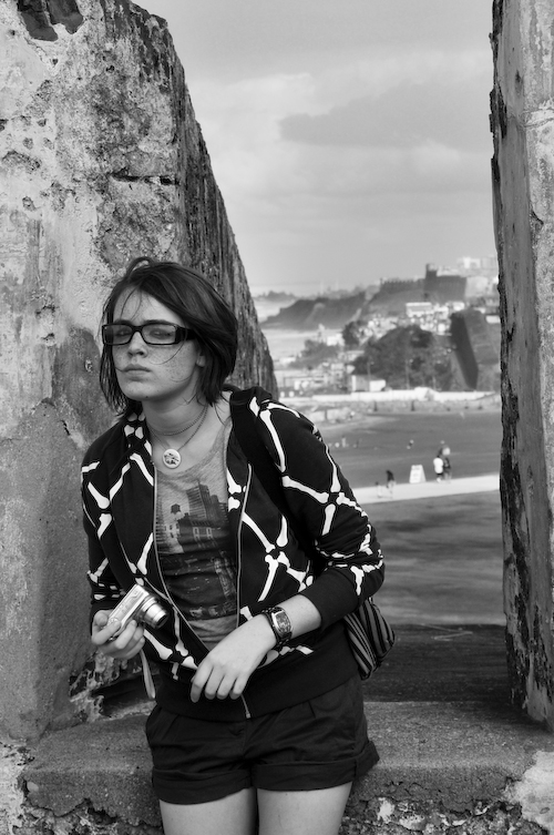
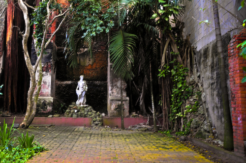
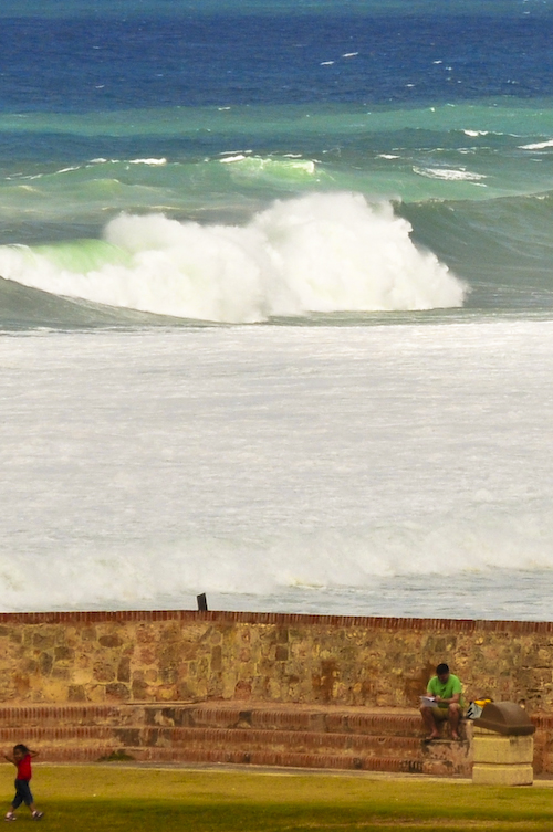
This was the view from my rather painful spot on the beach wall. Why painful, you ask? I dropped a 10 pound glass jar of sugar on my right foot this morning while making (what else?) my famous french toast, fracturing the next-to-last toe. Rather than go to the hospital and ruin the day for everyone, I hobbled along and shot my D300 from where ever I found myself plopped.

Ponce is well worth a visit, even if the beach isn’t ‘all that’. Ponce, the second largest city in Puerto Rico outside of the San Juan metropolitan area, is named after Juan Ponce de León y Loayza, the grandson of Spanish conquistador Juan Ponce de León. Ponce is often referred to as La Perla del Sur (The Pearl of the South) and La Ciudad Señorial de Puerto Rico (Majestic city of Puerto Rico).

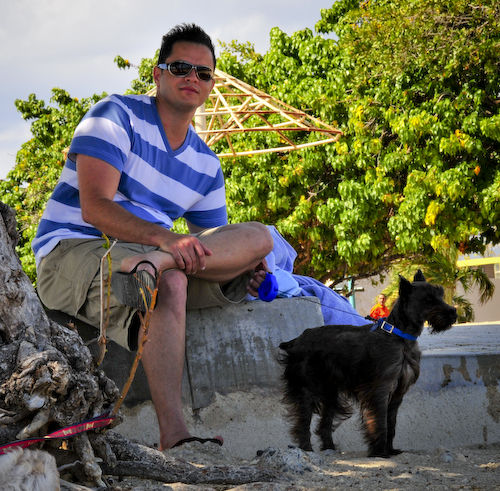
Regular readers of this journal will recognize my good friend Jesus, who was our chauffeur throughout the day. Jesus is a true friend – he drove us 500 miles and we enjoyed his company immensely. Jesus brought his dog Roger along for the ride, who was well behaved all through our long day.

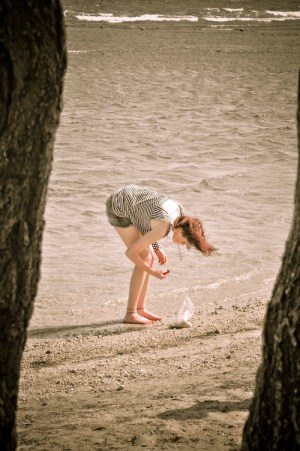
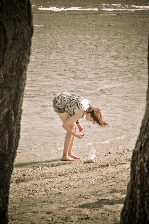
My daughter collected a few shells from the beach in Ponce. This photo was finished with a washed out look, and I really like the result.

Tucked away in the southwest corner of the island is the community of Cabo Rojo. There is a national seashore here, administered by the National Park Service. It is said that Cabo Rojo obtained its name from the considerable amount of minerals found in its coasts that made the waters look reddish. Cabo is the Spanish word for tip and analogous to the English word Cape in this context. The word rojo, translates to red. According to legend, the name was given by Christopher Columbus himself, although this is highly unlikely. The first church, founded in 1783, was called San José. The present-day main catholic church is called San Miguel Arcángel located in the town’s square.

Cabo Rojo Lighthouse

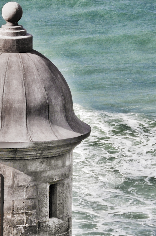
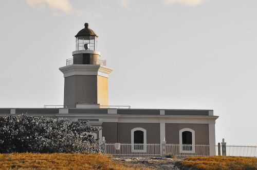
Located at the southwestern tip of the island of Puerto Rico, Los Morrillos Lighthouse was constructed in 1882 in order to guide passing ships through the southeast entrance from the Caribbean Sea through the treacherous Mona Passage into the Atlantic Ocean. The lighthouse is located over a while lime cliff which is surrounded by salt water lagoons and marshes. The cliffs surrounding the lighthouse drop over 200 feet into the ocean.

The lighthouse’s architecture is distinguished by its simplicity, with minimal decoration and an unelaborated cornice repeated through the structure. The illuminating apparatus is housed in a cast-iron, copper and glass lantern. The lenticular lens was manufactured by the French firm Sautter, Lemonnier and Company.

Originally, the lighthouse was manned by two keepers and an engineer, who lived on the grounds with their families. In 1967 the lighthouse was renovated and its operation is currently completely automated. The structure itself has been abandoned for decades, although recently the local government as well as local civic groups, such as Caborrojeños Pro Salud y Ambiente, are pushing towards turning the old lighthouse keeper’s house into a museum. The project was taken over by the municipality, an action that lost U.S. Federal government funds that had been assigned for it. The municipality took over the renovations, which, according to critics, has irrevocably damaged the historical significance of the internal structure.

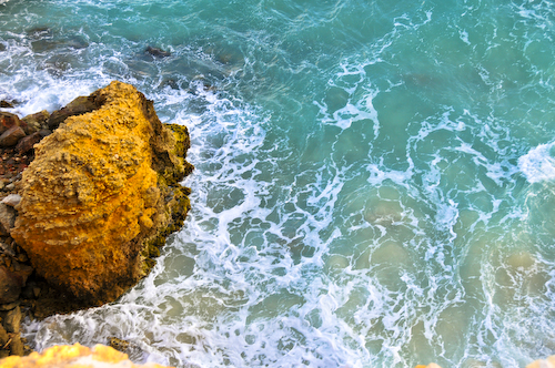
Here is the view down the 200 foot cliffs, over the red rocks below, and into the foaming sea. Cabo Rojo is just beautiful and well worth the drive across Puerto Rico.

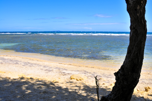
The third beach on our tour was in Luquillo, Puerto Rico. Luquillo is known as “La Capital del Sol” (sun capital) and “La Riviera de Puerto Rico” (Puerto Rico’s riviera). Luquillo was founded in 1797 by Cristóbal Guzmán. The town was named after the Indian cacique Loquillo, who died a few years after the last Indian rebellion in 1513.

Luquillo Tranquillo

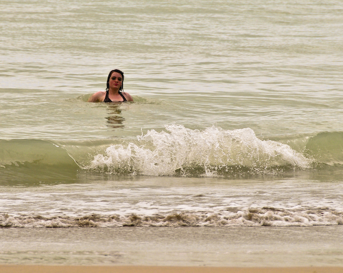
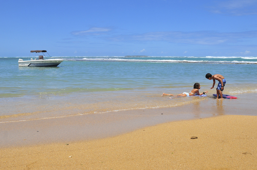
Here is my daughter relaxing in the gentle waves at Playa de Luquillo. A huge plantation of majestic coconut palms lining the beach shades more than a mile of fine sand. It is one of the most popular public beaches in the San Juan area. It offers cafeterias, public bathrooms with showers, access for disabled people, and an ample parking lot. This is one of the public beaches most frequented by the locals.

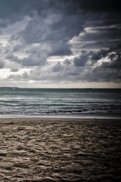
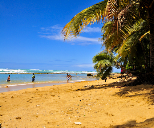
Finally, we visited Pinones, Puerto Rico. Vacia Talega beach is part of the long strip of beach comprising the ‘Pinones Nature Reserve’ just east of the San Juan Airport on Road 187. It is a very scenic way to drive east from San Juan.

Allthough it’s very beautiful this area is notorious for theft and you should never be on the beach alone nor park your car in a deserted area. If there are others at the beach, you’ll be fine here. Remember thieves can spot tourists by their rental cars and are tempted to open the trunk to see what cameras and wallets you’ve left for them! Despite the environmental challenges here, the beach is just beautiful.

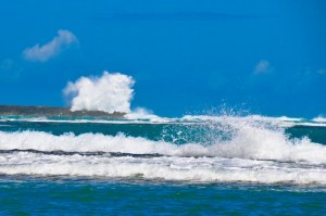
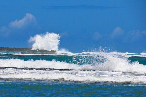
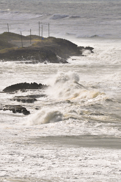
There is a reef just offshore which provides a spectacular aerial show when the surf is up. I estimated these breaks at 30 to 40 feet high – awesome!

The beach at Pinones is a mixture of coarse sand and coral. Although this area bears caution by tourists, the views are amazing and there are numerous fast food vendors nearby selling alcapurrias and other local treats. Alcapurria is a dish from Puerto Rico made from a mixture of ground plantains and yautia, filled with ground beef or crab meat and deep fried in vegetable oil. Many Puerto Ricans enjoy this dish and are often found eating it at the beach with friends.

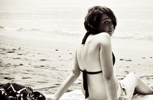
My daughter, shown relaxing in Pinones. This photo was finished with an acid wash treatment which I rather like. Shortly after this photo was taken we decided to hit the nearby stands where we scored some freshly made fried goods for the ride home. Mission accomplished!

*&

High Surf Warning!

•March 20, 2008 • Leave a Comment

“This coastal flooding is the greatest non-tropical cyclone related swell event experienced in the local area since the Perfect storm of 1991.”

– NOAA, 19 MARCH 2008, San Juan PR.

So began the day in Puerto Rico when my daughter and me arrived to enjoy a few days over spring break. We had originally intended to take the ferry to Culebra for a day of sun and fun, but the 30 foot waves at sea caused all ferry service to Culebra and Vieques to suspend for several days.

The view above was taken from Old San Juan looking eastward towards Condado and Pinones. Flooding in Pinones was extensive, causing evacuations and road/beach closures. Video footage form the local TV stations captured storm surges of several feet in some areas.

The wind, surf and sea spray were pretty amazing. These waves breaking near El Morro were 20 to 30 feet tall! It was also spring break for school-aged children in Puerto Rico, and the added benefit of high winds made kite flying a necessity.

Kites weren’t the only fliers today. Birds of all kinds enjoyed the constant breeze, including this Brown Pelican (Pelecanus occidentalis), which is the smallest of the eight species of pelican, although it is a large bird in nearly every other regard. It is 106-137 cm (42-54 in) in length, weighs from 2.75 to 5.5 kg (6-12 lb) and has a wingspan from 1.83 to 2.5 m (6 to 8.2 ft).

This bird is distinguished from the American White Pelican by its brown body and its habit of diving for fish from the air, as opposed to co-operative fishing from the surface. Groups of Brown Pelicans often travel in single file, flying low over the water’s surface. It eats mainly herring-like fish.

This red buoy, a type of sea mark which identifies the approach to San Juan Harbor, was having a rough go of it. The International Association of Lighthouse Authorities defines two systems of marks specifying the shapes, colors and characteristic lights of buoys, depending on their purpose. For historical reasons, there are two contradictory systems of lateral marks in use:

  • IALA System B in the Americas, the Philippines and Japan
  • IALA System A everywhere else.

The two systems differ principally in the colors used to denote the two sides of a channel. When approaching a harbor from seaward, System A places conical green marks to starboard and cylindrical red ones to port. In System B these are replaced with conical red marks to starboard and cylindrical green ones to port. This can be remembered (for System B) with the mnemonic “Red, right, return”. Another System B mnemonic, which also helps with buoy numbering is “Even Red Left Port” (as in Eric the Red) – Even Numbered buoys are red, on your left (port) side leaving port. In any case, since in many harbors it is not always apparent which direction is seaward, buoys should be used in connection with the appropriate nautical chart. Additionally, since marks may be off station due to collision with ships, storms or other factors, they should be used with caution and not relied on solely for navigation.

The shattered water made a misty din.
Great waves looked over others coming in,
And thought of doing something to the shore
That water never did to land before.
The clouds were low and hairy in the skies,
Like locks blown forward in the gleam of eyes.
You could not tell, and yet it looked as if
The shore was lucky in being backed by cliff,
The cliff in being backed by continent;
It looked as if a night of dark intent
Was coming, and not only a night, an age.
Someone had better be prepared for rage.
There would be more than ocean-water broken
Before God’s last Put out the light was spoken.

Once By The Ocean
Robert Frost